
Connecticut Faces Cold Wave With Snow Showers and Wind Gusts This Week
Connecticut is going through a very cold week with freezing temperatures and harsh winter weather conditions. Governor Ned Lamont has activated the Severe Cold Weather Protocol starting Monday, January 19, 2026, at 5:00 PM. This protocol will remain in effect until noon on Wednesday, January 21, 2026 due to the arctic blast. People living in Connecticut need to stay prepared because this cold wave will last for several more days. Snow showers and strong wind gusts will make things even harder for everyone trying to go about their daily life.
Very Cold Temperatures Are Staying Across Connecticut
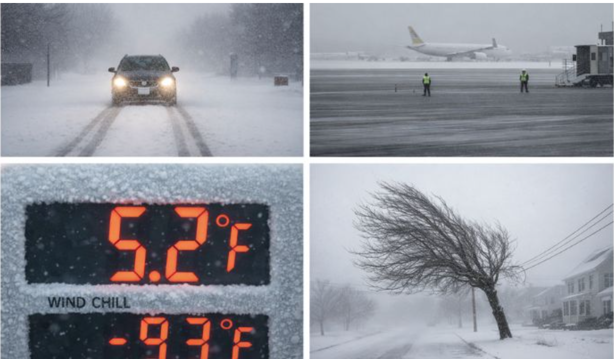
Connecticut remains under the grip of a strong cold wave as arctic air stays steady across the whole state. During the day, temperatures are expected to stay between 15 to 25 degrees, which is 10 to 15 degrees below normal. At night, the temperatures may fall into single digits, which is very dangerous for people who stay outside too long. Wind chill values will drop into the negative single digits at times, making it seem much colder than the actual temperature.
The early mornings and late evenings will be the coldest times, so people should avoid going outside then if possible. Officials are warning that this long, cold spell increases health risks for everyone, especially older people and children in the state. Residents should prepare themselves for several days of below-normal winter temperatures.
Snow Showers Will Move Through the State
Snow showers are expected to move through Connecticut from time to time during this cold wave period. Heavy snowfall is not expected, but brief snow bursts could happen and produce light snow on ground surfaces. Most areas will see less than one inch of snow accumulation, which is not a lot but still dangerous overall. The freezing ground temperatures may allow snow to stick quickly on roads and sidewalks that are not treated. Conditions can change from town to town, so what happens in one place may differ from another nearby area.
Even light snow can reduce how far you can see for short periods of time while driving or walking outside. Roads and sidewalks may become slippery very fast, even with small amounts of snow falling from the sky. People should keep checking weather updates because things can change quickly during this cold wave period across Connecticut.
Strong Winds Make the Cold Much Worse
Gusty winds will continue along with the cold wave and this makes the conditions even harsher for everyone. Wind gusts between 25 to 35 miles per hour are expected beginning Monday night and continuing through Tuesday morning. These winds will push wind chill values well below what the actual air temperature reading shows on thermometers around the state. In open areas, the gusts may blow loose snow around and reduce how far people can see clearly while outside. The mix of cold air and wind remains a big concern for everyone living across the state of Connecticut right now.
Power Outages Reported Across Multiple Areas
The cold weather and gusty winds have caused power outages in several parts of Connecticut this week already. Eversource reported that about 1,424 customers in Ashford were without power due to fallen tree limbs on Saturday. In Eastford, equipment damage caused around 244 power outages, while Tolland saw 368 customers lose power due to a crash. Hartford County currently has the most outages with 86 customers affected according to power outage tracking websites online.
Litchfield County is also seeing issues with around 114 customers currently without power in that area of the state. Utility crews are working hard to restore power, but strong winds have slowed down their repair work in many areas. Residents can check the Eversource Outage Map for real time updates on outages in their area.
Driving Could Become Dangerous at Times
Cold pavement combined with snow showers and gusty winds could make driving dangerous at certain times this week. Bridges and overpasses are especially likely to get icy even when the total snowfall remains very low overall. Brief drops in visibility may happen when snow showers pass through your area while you are driving somewhere.
Officials advise drivers to reduce speed and allow extra travel time when going out on the roads this week safely. Staying alert for rapidly changing conditions is important, especially when driving during early morning and nighttime hours. The coldest times are early morning and late night, so driving during those hours needs extra care and attention.
Flights May Get Delayed Due to Weather
Air travel at Bradley International Airport may see some delays as cold temperatures, light snow, and gusty winds affect operations. Even small snow events can slow down ground activity because planes need de-icing before they can take off safely. Runway conditions can also change quickly during winter weather, which causes problems for airport operations and flight schedules.
Gusty winds may also cause delays for planes that are arriving and departing from Connecticut airports this week. Travelers should check their flight schedules often and stay ready for possible changes or cancellations during this time period. Winter weather can disrupt air travel even without big snowfall, so staying flexible with plans is very important now.
Other Ways to Travel When Roads Are Bad
During times of extreme cold and snow, some people may choose not to drive themselves on the icy roads. This is especially true for longer trips or important trips that cannot wait until the weather gets better again. In these cases, professional transportation services can be a good choice because their chauffeurs know how to handle winter roads. While this is not needed for every situation, it can reduce stress when weather conditions remain tough across the state. Letting someone else drive means you do not have to worry about icy roads and can stay safe inside car.
Staying Safe Should Be the Top Priority
Authorities continue to tell people that safety should come first as this cold wave stays across Connecticut. Residents should dress in warm layers and make sure all exposed skin is covered when going outside in cold weather. Limiting time spent outdoors during the coldest parts of the day is very important for your health and safety.
Vehicles should be ready for winter with enough fuel in the tank and emergency supplies stored inside, just in case. Utility and emergency crews are staying alert and ready to help with any problems caused by wind and freezing temperatures. Those who need shelter can call 211 to find warming centers and get transportation to safe locations in the state. These winter conditions are expected to continue for a few more days before things slowly start getting better for everyone.